
Telluride to Ouray CO

Thread Starter
I think I can... I think...
Joined: Aug 2004
Posts: 2,264
Likes: 0
From: Texas (DFW area)
Anyone here ever take the drive over Imogene Pass from Telluride to Ouray?
I've been told that my Mega cab can make it but will have to make a few 3 point turns and there are some rock crawling situations that could cause my rear end to drag as well as pucker!!! Maybe some large planks in the back for those possible drag points? Bigger than factory tires?
Supposedly alot of the guides take Dodge pickups through there. I would assume short beds for sure.
Thread Starter
I think I can... I think...
Joined: Aug 2004
Posts: 2,264
Likes: 0
From: Texas (DFW area)
So it looks like your video is mostly Black Bear?
I assume that they connect?
Do you have more of Imogene?
With age comes the cage
Joined: Jul 2007
Posts: 2,710
Likes: 3
From: The Gas Patch
Ron,
Yes most of that footage was BB which is no place for a meg-cab
I have more of Imogene in the raw file folder I will try to get some of it pieced together and another vid made. (do a search on youtube for it as well) When were you thinking about going that way?
There is a lot of loose busted up shale rock that way be sure you have an AC & plugs for the journey:
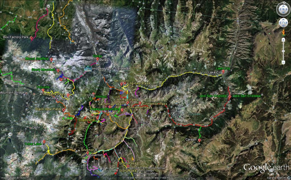
Here is a mega map of the area:
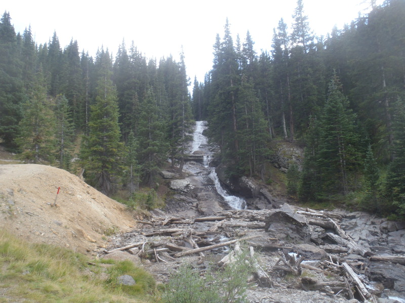
This is from the Telluride side looking towards the top of Imo:
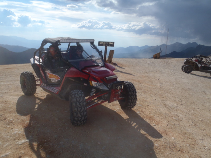
The top of Imo:
Back towards Ouray:
Make sure you ride the narrow gauge train from Silverton - Durango
There is a lot of tour guides both full size and ATV for the area that will take you places no Mega-Cab will go
Yes most of that footage was BB which is no place for a meg-cab
I have more of Imogene in the raw file folder I will try to get some of it pieced together and another vid made. (do a search on youtube for it as well) When were you thinking about going that way?
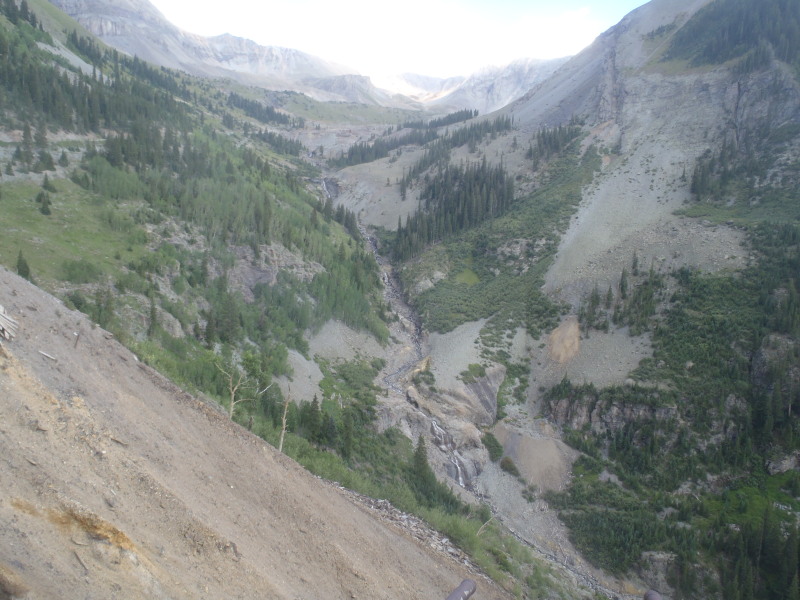
There is a lot of loose busted up shale rock that way be sure you have an AC & plugs for the journey:
Here is a mega map of the area:
This is from the Telluride side looking towards the top of Imo:
The top of Imo:
Back towards Ouray:
Make sure you ride the narrow gauge train from Silverton - Durango
There is a lot of tour guides both full size and ATV for the area that will take you places no Mega-Cab will go
Thread Starter
I think I can... I think...
Joined: Aug 2004
Posts: 2,264
Likes: 0
From: Texas (DFW area)
Ron,
Yes most of that footage was BB which is no place for a meg-cab
I have more of Imogene in the raw file folder I will try to get some of it pieced together and another vid made. (do a search on youtube for it as well) When were you thinking about going that way?
Yes most of that footage was BB which is no place for a meg-cab
I have more of Imogene in the raw file folder I will try to get some of it pieced together and another vid made. (do a search on youtube for it as well) When were you thinking about going that way?
Most of Imogene looks really tame in these vids but I did see one spot where jeeps were crossing a creek and the rear end of the jeep looked really close to scrapping the rear bumper.
This one has the creek crossing
I don't want to beat up my truck but I would like to take advantage of owning a 4WD. I'm well versed on dirtbikes and little experience with 4WD but common sense always comes first for me. Not a fan mistakes, damage or severe personal injury!!!
We are staying in Bayfield, CO and arrive on Oct 3rd.

Here is a mega map of the area:
This is from the Telluride side looking towards the top of Imo:
The top of Imo:
Back towards Ouray:
Make sure you ride the narrow gauge train from Silverton - Durango
There is a lot of tour guides both full size and ATV for the area that will take you places no Mega-Cab will go
This is from the Telluride side looking towards the top of Imo:
The top of Imo:
Back towards Ouray:
Make sure you ride the narrow gauge train from Silverton - Durango
There is a lot of tour guides both full size and ATV for the area that will take you places no Mega-Cab will go
With age comes the cage
Joined: Jul 2007
Posts: 2,710
Likes: 3
From: The Gas Patch
Ron,
As I recall that creek crossing has about 3 different options to it (I have done a 1,000 miles of trails since it thou) Worse case scenario is to build it up with some rocks so as not to drag the low hanging parts. If you look at the picture you can go back North to Gov Basin then catch Camp bird road to get back to Ouray
If your staying in Bayfield go to the top of Red Mtn pass and take the Ophir pass road to get you into Telluride Via 145 then from Telluride take Imo to get back to Ouray. Other trails to consider is the Alpine Loop from Silverton to Eureka to Animas Forks to Engineer Pass to Lake City to Lake San Cristobal to Cinnamon pass back to Animas Forks..
This is part of the do not drive with a full size truck list:
Black Bear Pass
Mineral Creek
Poughkeepsie Gulch (this one will kick your axle for sure)
Corkscrew Pass
Stony Pass
Keep in mind Oct can bring early winter storms so be prepared!
Thread Starter
I think I can... I think...
Joined: Aug 2004
Posts: 2,264
Likes: 0
From: Texas (DFW area)
Ron,
As I recall that creek crossing has about 3 different options to it (I have done a 1,000 miles of trails since it thou) Worse case scenario is to build it up with some rocks so as not to drag the low hanging parts. If you look at the picture you can go back North to Gov Basin then catch Camp bird road to get back to Ouray
If your staying in Bayfield go to the top of Red Mtn pass and take the Ophir pass road to get you into Telluride Via 145 then from Telluride take Imo to get back to Ouray. Other trails to consider is the Alpine Loop from Silverton to Eureka to Animas Forks to Engineer Pass to Lake City to Lake San Cristobal to Cinnamon pass back to Animas Forks..
This is part of the do not drive with a full size truck list:
Black Bear Pass
Mineral Creek
Poughkeepsie Gulch (this one will kick your axle for sure)
Corkscrew Pass
Stoney Pass
Keep in mind Oct can bring early winter storms so be prepared!
Thanks for the tips!! BTW your google earth map with the trail lines. Is that the picture you're referring to above and is that an overlay that you've done with your GPS or is that something that can be accessed online?
As to weather, I will certainly watch the weather and forcasted weather. The last thing I wanna do is get stranded on the pass or somewhere along the way!!

Trending Topics
With age comes the cage
Joined: Jul 2007
Posts: 2,710
Likes: 3
From: The Gas Patch
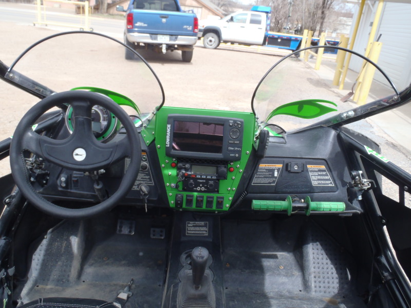
Yes all of those trails are on my chart plotter, I drive the trails on Google Earth with the mouse finger in the winter then with the buggy in the summer. I use Expert GPS software to import the KMZ files from GE then export it to the USR format required for the Lowrance units. (Most handhelds are a GPX format)
Here is what the dash looks like now with the comm. equipment installed (I designed and built it myself):
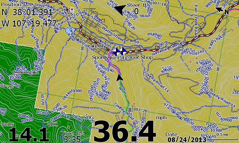
This is a "screen shot" (as seen on the chart plotter) from the Alpine Loop ride (Engineer Pass to Lake City section):
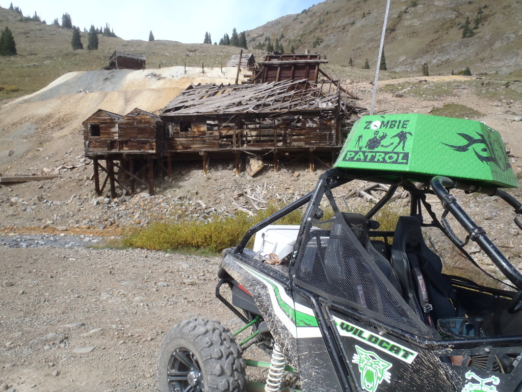
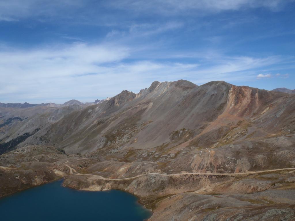
Here is some more pics from the Alpine Loop side of the road...
Animas Forks:
Lake Como (Poughkeepsie Gulch is the road to the left at the bottom):
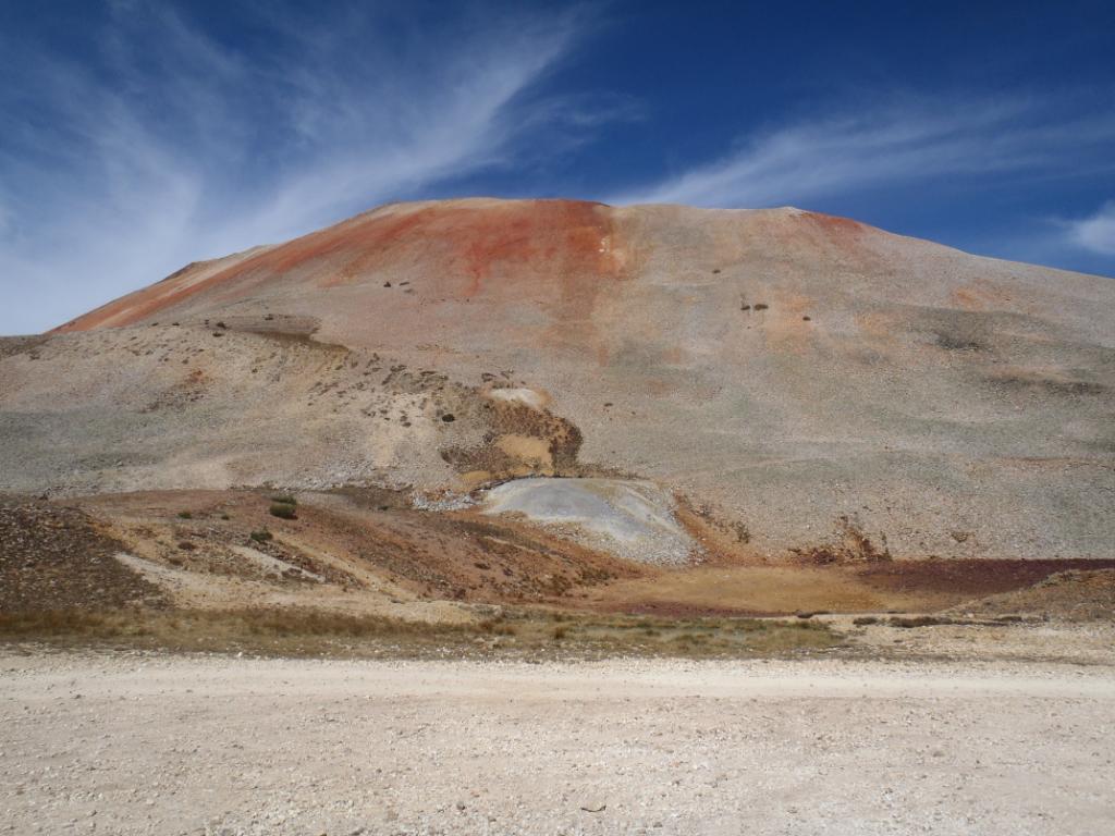
The Red of Red Mtn Pass (taken at the top of Corkscrew Pass):
PM me your email addy and I will send you the GE KMZ file.
Here is what the dash looks like now with the comm. equipment installed (I designed and built it myself):
This is a "screen shot" (as seen on the chart plotter) from the Alpine Loop ride (Engineer Pass to Lake City section):
Here is some more pics from the Alpine Loop side of the road...
Animas Forks:
Lake Como (Poughkeepsie Gulch is the road to the left at the bottom):
The Red of Red Mtn Pass (taken at the top of Corkscrew Pass):
PM me your email addy and I will send you the GE KMZ file.

Registered User

Joined: Aug 2002
Posts: 1,227
Likes: 50
From: Castle Rock, CO
Just saw on the news last night that a jeep rolled on Black Bear, came what appeared to be within 20 feet of rolling down the entire mountainside.
http://www.thedenverchannel.com/news...lack-bear-pass
http://www.thedenverchannel.com/news...lack-bear-pass
With age comes the cage
Joined: Jul 2007
Posts: 2,710
Likes: 3
From: The Gas Patch
Here's some more reading on it from the Telluride paper:
http://telluridenews.com/articles/20...8507626090.txt
http://telluridenews.com/articles/20...8507626090.txt
Thread Starter
I think I can... I think...
Joined: Aug 2004
Posts: 2,264
Likes: 0
From: Texas (DFW area)
Here's some more reading on it from the Telluride paper:
http://telluridenews.com/articles/20...8507626090.txt
http://telluridenews.com/articles/20...8507626090.txt
Hey Co-Ram, don't forget to email me!!! ;-)
With age comes the cage
Joined: Jul 2007
Posts: 2,710
Likes: 3
From: The Gas Patch
Sent your way Capt Ron!
More local info links:
http://silvertoncolorado.com/
http://silvertoncolorado.com/backcountry-updates/
More local info links:
http://silvertoncolorado.com/
http://silvertoncolorado.com/backcountry-updates/